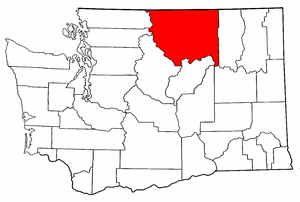
Okanogan County
- State
- Washington
- County Seat:
- Okanogan
- Year Organized:
- 1888
- Total Square Miles:
-
5314.793
- Population:
-
41742 (2017)
- Persons/Square Mile:
- 8
County structure
- Government Type:
- County
- Authority:
- Dillon's Rule
- Legislative Body:
- Board of Commissioners
- Size of Legislative Body:
- 3
Demographics
- 2018 Population:
- 41742
- 25 to 64 Years of Age:
- 48.50%
- 65 Years of Age and Older:
- 21.58%
Economy, 2018
- Gross Domestic Product (GDP):
- $1.4 B
- Labor Force:
- 20,808
- Unemployment Rate:
- 6.40%
Okanogan is a county in the state of Washington. The state borders Canada. The recent census found that about 14,120 people were living in the county as of 2010. The county has a wealth of land and natural minerals, covering a massive area of the entire state.
Okanogan county seat is Okanogan. Also, the largest town is in Omak, and most residents in the county live in the city. The county was a break-off from Steven’s county in February 1888.
History
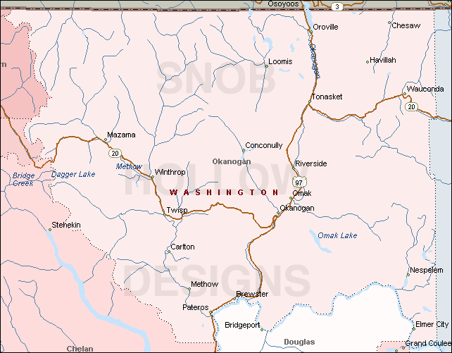
Okanogan is a remote area in which indigenous Indian tribes still reside. However, it connected as a thoroughfare for people traveling to British Columbia in search of gold. The county borders Stevens and Lincoln. It is also the home to the Columbia River and the Coulee dam.
The original residents were red Indians who now form reservations in the area. There are Konkonelps, Tokoratums, Kartars are known as Southern Okanogans. They had varied interior Salish dialects.
The climate in the area has always been favorable for the indigenous tribes. They would hunt deer in fall, camp during winter, fish in summer, and hunt bears during spring. One of the earliest campgrounds was at the Kettle Falls. The falls are 20 Feet long along the Columbia River.
Europeans spend a long time accessing the area due to its geographic ruggedness. However, the first American to settle here was Hiram Okanogan Francis, who moved here in the 1850s and 60s. Another was John Utz, who was keen on staying in the area. He went on to become a political and commercial leader.
Other settlers would find their way in during the period. Many were miners who were on their way to find gold and riches in the British Columbia area.
As the native tribes refused to sign treaties with the US government to offer their land, they kept their region intact. However, in 1871, there was an executive order that allowed the government to create reservations. Ulysses Grant created the Colville Indian Reservation.
The Colville Indian reservation was home to Spokane, Methows, San Poils, Couer D’Alenes, Colville, Lakes, and Okanogans. The non-natives in the area that had homes lobbied the government to remove them from the reservation.
In 1886, the government reduced the reservation area to make Colville a contemporary Indian Reservation. It is home to Colville confederated tribes.
Geography
The county has an area of 5,315 square miles. Water covers 0.9% of the county. The county expands to list as one of the largest counties by area. It is larger than three states in land area.
Okanogan is home to many notable geographical features like rivers, Columbia and Okanogan, the Beaner lake, and the cascade mountains. It is also home to North Gardner mountain.
The county has one of the leading power producing rivers. There are three plants that serve the Okanogan area.
Notable highways are traversing the county. Some of the transport lines include the National route 97. Also, there are two state roads in the state route 20 and 153.
Economic activities
Most people who settled in the area were miners on their quest to find gold and silver. There were several camps where they would reside. The first was Ruby city which later got the name Ruby. Loop, Solver, Oro, Conconully, among others. The establishment of mines and small camps or towns saw the number of non-natives balloon to 1509 in 1890.
However, the 1893 panic and the silver purchase act would affect the market price of the valuables. The production was at an all-time low. While mining was valuable in the 20th century, the county was never the best at gold production in the state.
Agriculture is a significant economic activity in the area. It employs about a quarter of the working population in the county. Though the number has been dwindling lately, beef and wheat farming earns the county decent revenue. There is widespread wheat growing in the area. Also, cattle ranching and beef production is a vital part of the economy. Other types of faring include the cultivation of fruits.
Outdoor activities are in plenty in the area. Most people visit the county for arts and entertainment. Frequent tourists include hikers and people looking to enjoy several seasonal outdoor activities like skiing and horseback riding. There are numerous entertainment points and activities like horseback riding and festivals that attract tourists. Additionally, visitors book in some resorts to enjoy their time in the county.
Other notable sources of income include forestry, fishing, retail, and other service industries.
Cities and towns
There are notable towns and cities in Okanogan County, housing almost the entire population. Okanogan, Brewster, Tonasket, Oroville, Omak, and Pateros are big cities in the county. Additionally, towns in the county include Conconully, Elmer city, Riverside, Twisp, Winthrop, and Nespelem. A part of Coulee dam town is in Okanogan.
There are designated census areas, like Desautel, Nespelem community, Methow, Loomis, Malot, and North Omak.
Other ghost towns include Ruby, Molson, Chesaw, Boster, and Bodie.
County offices
The county offices are in Okanogan was originally in Ruby town. However, in the present day, Ruby is a ghost town. The county seat would later move to Conconully after eight months. Later, voters made Okanogan the home to the courthouse in 1914, settling as the county seat.
All county offices are in Okanogan city. The courthouse takes care of legal and judicial matters. Also, the Auditors office can handle state-related issues. Residents can access public records as stipulated by the law.
Some of the documents to find in the county clerk’s office include.
- Land and property ownership documents like deeds
- Ownership and deed records
- Structural details
- History of deeds
- Marriage, death, and birth records
- Business documentation and legal licensing
You can reach the Okanogan county clerk through the number 509-422-7170.
Okanogan county court
There is a district court in Okanogan county. They can take care of the following matters.
- Criminal such as misdemeanor and gross misdemeanor
- Small claims of $10,000 and below
- Vehicle impounds
- Changing your name
- Protection orders
- Vacate convictions
- Infractions
You can find the judge and a presiding judge. The courthouse is open every weekday between 8.30 am and 4.00 pm.